|
|
November 4, 2000 Brian Jacobs Presents Cruising the California Coast |
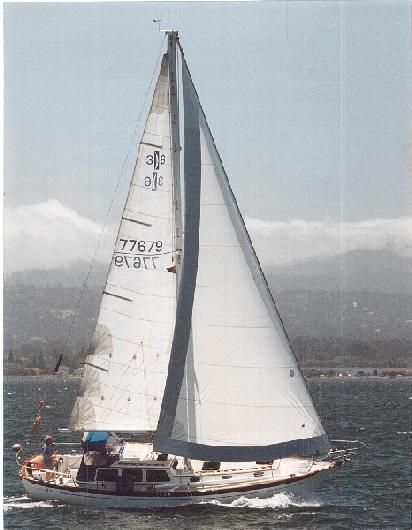
Blue Moon close hauled on San Francisco Bay looking west to the hills and fog south of San Francisco airport.
(Click Pic to enlarge.)
We have now made two round trips between San Diego and San Francisco. The most recent trip was from San Francisco to San Diego, completed on October 20, 2000.
There are two versions of our travels, one from Fran, and one from me. As always, ladies first.
Fran's Version
We bought the boat in San Diego, after much yard work including an epoxy bottom; Brian and his delivery crew brought the boat up to Coyote Point. Brian said the trip was pretty rough.
Last year, Brian and I, with some friends as crew, sailed the boat from San Francisco to San Diego. It was a great trip and I really enjoyed it.
This spring, Brian and some friends brought the boat back up to San Francisco from San Diego. The weather was not terribly cooperative. After several driving trips to various ports to bring Brian and the crew home while waiting for breaks in the weather, they finally got the boat back to Coyote point. That 6 day passage took 3 + weeks. Brian said the trip was pretty rough.
This fall, Brian and I and our son took the boat back down to San Diego. We had a great time.
Brian will be bringing the boat back up to San Francisco this spring. The trip will probably be pretty rough.
Fran Jacobs
BRIAN'S VERSION
The first trip going north was several years ago, and I have forgotten much of the hardship, much in the same way women forget about the trial of childbirth. Otherwise, BlueMoon would still be in San Diego, and we would all be "only" children.
Last year going south was a very pleasant trip, and we had prepared for it well. The boat was in good condition, and we drove the coast in our car and stopped in each harbor we planned to visit. We made notes of any unusual conditions and the location of the harbor patrol etc. This eliminated the stress involved in going into strange harbors. I will combine the 2 trips south, discussing the most interesting parts of the each.
We did the trip in several steps, taking 2 weeks to complete the voyage. Both years, Fran and I took the boat ourselves from SF to Halfmoon Bay, Santa Cruz, and Monterey, then picked up crew in Monterey for the remainder of the trip.
In general, we follow the 3-mile line. It coincides pretty well with the 30-fathom line as well. By staying there, if the only instrument working is your depth sounder, just stay at 180 feet and you will be OK.
San Francisco to Halfmoon Bay is pretty easy, but you need to be aware of the tide going out The Gate. It's best to go at slack tide. Depending on conditions you need to decide whether to take the south channel or go out to at least the first buoy in the main shipping channel before making your turn.
Half Moon Bay had slips available both years, but the anchorage is easy to use if necessary. Santa Cruz is a great stop. The only transient accommodations are end ties, and you agree in advance to raft. We have always had to raft there and find we meet really nice people.
Our first trip across Monterey Bay was a little stressful. We left Santa Cruz in total blue sky and sunshine, and 10 knots of wind. Within 10 minutes, we were in total fog. Fortunately I had just installed radar, and I was sure happy about that. As we approached Monterey I called the harbormaster, asking if we might get an escort into the harbor. He asked why? I explained the fog situation, and he said there was nothing but blue sky and sunshine, and so it was, beginning about a mile from the harbor. When calling the harbormaster at Monterey for a slip, don't do it with your cell phone. They only assign slips by radio when you are clearly close enough for good VHF communication. That's how they determine who is first.
Our strategy for timing was to always get to a harbor by 4:00 PM, assuming 5 knots. For the overnight passages involved on this trip (Monterey Bay to Morro Bay, and Morro Bay to Santa Barbara) we planned to pass Point Sur and Point Conception at around midnight, or at least late enough so the wind will have died down. After the overnights, we arrive early enough to get settled, eat and rest.
We stayed in Monterey a couple of days, our crew joined and we set out on an overnight sail to Morro Bay.
The passage from Monterey was in total fog. You could not see the top of the mast with a flashlight. We had more wind than we really wanted, but it was OK. Just as we were going to start our sleeping shifts, we were joined by a large group of dolphin. They stayed with us for more than two hours, dropping back, racing up, crossing the bow, just having a good old time. We could barely see them for the fog, but they went through the "glow in the dark" algae, and they looked like green torpedoes going through the water. We got so excited watching them that we all stayed up the rest of the night. We stopped at San Simeon long enough to take Bailey to shore and get a couple hours rest, then we went on to Morro Bay. This year, we made such good time; we got to San Simeon while it was still dark, so we didn't stop until we got to Morro bay.
We so enjoyed staying up all night together, that we changed our plan regarding sleeping. Now we plan to all stay up all night together, and stay an extra day at the next stop to catch up on sleep.
Morrow Bay is a fishing port, and they make no provision for transient pleasure boats. If you are in trouble, they will graciously come out and get you and put you in a slip. If you are not in distress, they refer you to the yacht club. The Morro Bay yacht club is great. They have a long dock that can hold 3 or 4 boats, and you are expected to raft up. In special circumstances, the harbormaster allows rafts 3 deep. Immediately across the fairway from the yacht club, there are 8 numbered buoys that belong to the club that you can use. There is a very strong tidal current in the channel, as much as 7 knots, so be aware.
Next of course is the passage around Points Arguillo and Conception. We leave Morro Bay around noon, putting us at Conception around midnight. The first year it was a piece of cake. We had to motor around the points, not so this year. This year we had 22-knot winds, and 13-foot swells. That over powered our autopilot, so we hand steered for hours. We also did a semi-uncontrolled jibe in the turmoil. We did the jibe perfectly except we forgot to lock down the traveler. So after a perfectly executed jibe, the traveler slammed from port to starboard, leaving the bottom half of the car, including the bearings, on the track, and the rest held together by knots in the lines a couple of feet up in the air. We had no real control of the mainsheet, but it was on a run, so we managed. Fortunately we had a replacement car, but that's another story.
I had explained to our son Brad that as soon as we turned the corner to head east, it would be like a different ocean, calm, warmer, etc. Right! The wind piped up to 30, but the swells were smaller. This continued until we passed Gaviota by a couple of miles, then you couldn't find a ripple on the sea as far as you could see. It stayed that way all the rest of way to San Diego. My credibility improved. Because of the high winds, our planned 5-knot speed had become 7+, and we got to Santa Barbara at 4:30 AM instead of our planned arrival at 8:00 AM. Let me simply say Santa Barbara harbor is not one to go into at night. Because of 33 year old sharp eyes and a 500,000 candle power spotlight we made it safely in. When I mentioned to the harbor master about the difficulty entering the harbor, she told me of the plans for next year, and said; " next time just call us on the radio and we will be glad to come out lead you in, we do it all the time. Gives us something to do in the middle of the night"
We stayed in Santa Barbara for 2 days and had a great time. For inexpensive terrific food and cheap drinks there is a sports bar called Madison's on State Street. Can't be beat, especially during happy hour, 4 to 7 PM.
From Santa Barbara we did an easy day to the channel Islands Harbor at Oxnard, stayed overnight then went to Marina Del Rey. Be sure to go into the harbor through the north (or west) end of the breakwater. Go in under power. The other end gets shoaled they say. Once inside, be sure to stay inside the marker buoys, leaving the center channel for the sailors who want to tack. The guest docks are in the very first finger to the right, on the left side. There are also some guest docks just around the corner at the outside end of the same finger. Nice place, but about a mile to walk to any restaurants.
From there we went to Newport Beach Harbor. This is a really nice place to stop. You can walk to Balboa Island for shopping and restaurants. One time we stayed at the Newport Yacht club, super nice. This time they were full, so we stayed at the transient docks. The slips are very narrow, and there is a combination of wind and a strong current running perpendicular to the slips. We had a very difficult time getting in. I have no advice but to do it at slack tide if possible.
From Newport we sailed to Oceanside Harbor. Along the way we encountered a gigantic school of dolphin. There were thousands of them, as far as you could see. I don't understand this, but it completely made my radar screen go black. I thought I was about to hit an invisible freighter.
Last year there was a strong south swell, and we barely escaped disaster going in and out of the harbor. It's not worthwhile going there if there is a strong south swell and wind. Same for Morro Bay and Santa Cruz!
This year Oceanside was fine, and there was a movie being made in the slip two over from ours. It is an independent movie called "Son of the Healer". It is not impossible that both BlueMoon and Bailey may be in the film.
From Oceanside we sailed to San Diego, arriving to a VHF broadcast from the Coast Guard that the channel would be closed for several hours to accommodate the pacific fleet sailing into the bay for "Fleet Week".
Upon further conversation with the Coast Guard, we were allowed to go into the bay by staying just outside the marked channel. Two warships I couldn't identify passed us, also two very high-speed landing craft, an aircraft carrier and a submarine. It was pretty awesome.
The Trip(s) North
Going south in the fall is fun, relaxing, and a vacation. Not so going north in the spring as I have now done twice.
Pretty much going from San Diego to Santa Barbara is the same as that leg going south. Easy, no big deal if you watch the weather even a little. But, that's the end of the vacation. I must say I learned a lot on this last northbound passage, my first as the skipper, especially about weather. Simply put, going north is a delivery, and a difficult one at that. Basically, you have to wait for approaching low-pressure systems, then jump on the south wind it generates and go as far as you can before the next high comes in. When a low is coming, the wind dies down, the sea flattens out, and you have about 18 hours before the next high. You have to be really aware of the forecasts, and be sure you won't be depending on a south-facing harbor. Those are Oceanside, Morro Bay, and Santa Cruz.
At the end of this section, I have included some weather resources, which I will discuss.
From Santa Barbara we tried to get to Coho Anchorage, just before Point Conception. The wind and waves were too much, and we turned back as we neared Gaviota. Gaviota has a low spot in the mountains where the same wind you will encounter north of Conception has a chance to show you its stuff. Further we got to see some clouds just lying stationary on top of the mountains. Stationary with all that wind! The locals call those clouds "the fingers of death". If you see them, go back or duck into Coho if you can get there. Coho is not lighted in any way, but there is a large ship stationed there called Mr. Clean. It is there to respond to oil spills and is lit up like a small city. The local fishermen told us that if we insisted on getting to Coho, to hug the shore, � to one mile off at the most, to stay out of some of the wind and waves. Also, you must motor into the wind with your main sail up and sheeted in tight or you get needlessly tossed around.
We went 7 hours back to Santa Barbara, waited for a low, and went back to and around Conception all the way to Morro bay without incident. There are lots of fishermen to talk to in Santa Barbara, and at the fuel dock there is a free touch screen computer with connection to every weather service there is.
We tried to leave Morrow Bay into what seemed like lower velocity northwest winds, but again we turned around and went back. We went to a bar, bought some fishermen we had met earlier a beer and got the clear dope on when not to leave Morrow Bay. " If you see us here, drunk on our ass, it's because we can't go out there and make a living. When you come in here and we are not here, it is safe to go".
After a car ride home, we returned a week or so later when a low was on it's way, and had a decent trip all the way to Monterey, our intended destination. The wind was from the south so strong that we arrived at the corner of Monterey Bay hours earlier than we expected, so we decided to push on to Santa Cruz.
That was big time skipper error. We got to Santa Cruz in way too much wind, to find the entrance to the harbor blocked by massive, breaking waves. None of the commercial or pleasure boats could go in or out. Commercial boats anchored near the pier were washed way up onto the beach. The harbormaster said from her perch, all she could see was a green wall of water. We had to decide whether to continue north or go back 20 miles into the face of the wind and waves to Monterey. My crew was pretty tired, and scared to boot, so we decided 4 hours to Monterey was the best choice. Well, thank goodness we had a sailboat. At full power, going on the direct line to Monterey, we could barely make 2 knots on the GPS. So we fell off the wind, under double reefed main and full power, and made it into Monterey in around 4 hours. Another car ride to Los Gatos followed, waiting for the next low to be on its way. The weather finally cooperated and a friend from our Yacht club and I jumped on the southerly at 6 PM one evening and sailed, engine off (just to do it) into the slip at Coyote Point at around 2:00 the following afternoon.
Some Weather Sites and Comments
The first 4 sheets are samples of the buoy data available. The site starts with the map of the world. National Data Buoy Center You then click on the southern half of CA, and the next page pops up, showing the location of the buoys. U.S. Southwest Regional Map You click on the one of interest, and get real time info at the buoy (sheet 3) #46012 Half Moon Bay example and 24-hour historical data, swell and wave data. (Editor's note: This same data, plus forecasts, is available at NWS - SAN FRANCISCO BAY AREA MARINE WEATHER with a list of the buoys.)
This now has new meaning to me. When in Santa Barbara, a delivery Captain that my crew friend knew, told us that because of the underbody shape, Islanders won't go into big swell that is less than 10 seconds apart. He said he wouldn't leave Santa Barbara going north until the interval is 12 seconds or more. From the graph on sheet 5 you can see why. The wave energy you are fighting at 10 seconds is enormous. It drops all at once down to practically nothing at around 12 to 14 seconds. When they are too close together, you get stopped before you can get going, thus the 2-knot speed. Falling off and tacking is the only answer if you must go.
At the end of each buoy report there is an option to link to wave spectrum plots of energy vs period in seconds. This is the technical display of this phenomenon.
Sheet 6 is a wind model that can be useful; I don't especially care for it because it is difficult to read, but here it is: Winds Speed/MSLP (Mean Sea Level Pressure)
Sheet 7 is a somewhat useful wave model, it gives you an overview, but the wave information from the buoys is more useful. Pacific Regional Sea State Analysis
The next two are my favorites.
Sheet 8 is Intellicast. It is a wind model that has several selectable time periods. Today, tomorrow and the next day. Basically 3 time choices per day. I have found this model most accurate and helpful. The subtle difference between this model and the forecast from the buoy sheets is that the wind is often much calmer near shore than even a few miles out. The reports from the VHF and from the buoys lump together everything from 0 to 20 miles out, and then they give you the highest velocities. So whether you are looking for more wind or looking to avoid too much wind, this is the best model I have found. San Francisco WINDcast
The last sheet is the best kept secret of all, and you must agree not to abuse it, lest it goes away. Most of the weather reports originate at the Oxnard branch of the national weather service. If you call them and ask for more information or advice, they will read you the same report you can get on the buoy sheets. If you call the Eureka station, you will want to know where to send money. When you call them, and say something like: "I am in Morrow bay with a 36 foot sailboat, and I want to go to Monterey. Can you help me figure out when would be a good time to avoid really bad winds and swell"? They will sit down at their computer with multiple models and tell you how far from shore, what day and what time the swells will be how high and the wind from what direction and how strong it will be blowing. They are just the most helpful and knowledgeable folks you are likely to encounter. Eureka, CA
Brian Jacobs
BlueMoon
| Return Main Menu |